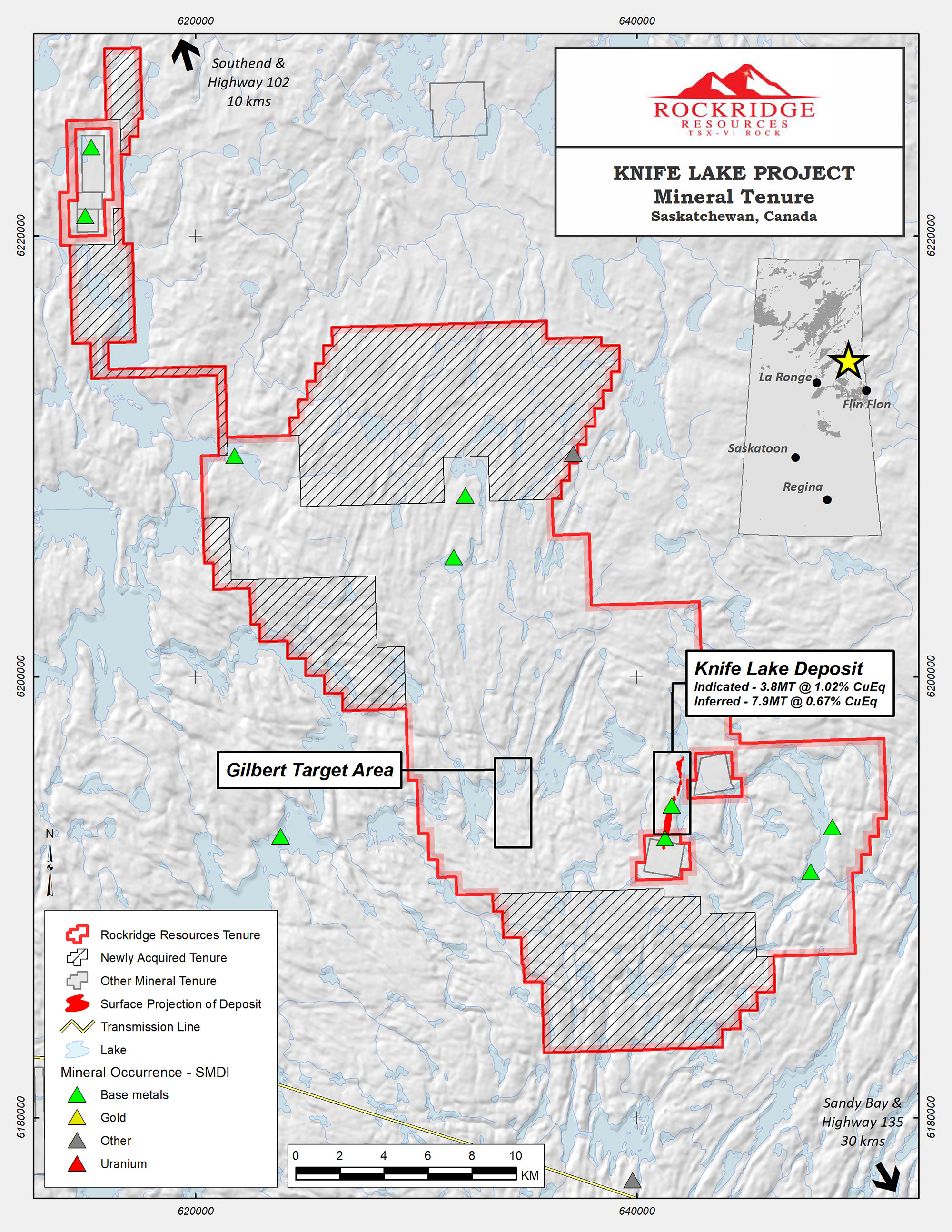
The Knife Lake Project consists of 58 claims totaling 45,168 hectares (111,612 acres)
The Knife Lake Project area is an advanced-stage copper, silver, zinc and cobalt exploration property in Saskatchewan; extensive exploration was completed from the late 1960’s to the 1990’s, with the last documented work program completed by previous operators in 2001
Rockridge completed the first work program in the last ~20 years in 2019, with highlight results including 2.03% Cu, 9.88 g/t Ag, 0.19 g/t Au, 0.36% Zn, and 0.01% Co (2.42% CuEq) over 37.6m beginning at 11.2m in hole KF19003
Deposit is a remobilized portion of a presumably larger “primary” VMS deposit; most of the historical work has consisted of shallow drilling at the deposit area with little regional work carried out and limited deeper drilling below the deposit
Over 300 holes provided data for the first NI 43-101 resource estimate of the shallow Knife Lake deposit
Knife Lake NI 43-101 resource estimate provides excellent anchor for Project:
Ind. resources: 3.8 MT @ 1.02% Cu Eq.
Or 3.8 MT @ 0.83% Cu, 3.7 gpt Ag, 0.097 gpt Au, 82 ppm Co,1740.7 ppm Zn.
Inf. resources: 7.9 MT @ 0.67% Cu Eq.
Or 7.9 MT @ 0.53% Cu, 2.4 gpt Ag, 0.084 gpt Au, 53.1 ppm Co, 1454.9 ppm Zn.
Rockridge completed the 2021 drill program which was expanded to 2,043.0 metres and consisted of twelve drill holes
Infill drilling was conducted and returned highlight intercept from hole KF21021: 1.95% Cu, 0.11 g/t Au, 7.41 g/t Ag, 0.53% Zn and 0.02% Co (2.34% CuEq) over 14.02m beginning at 24.62m
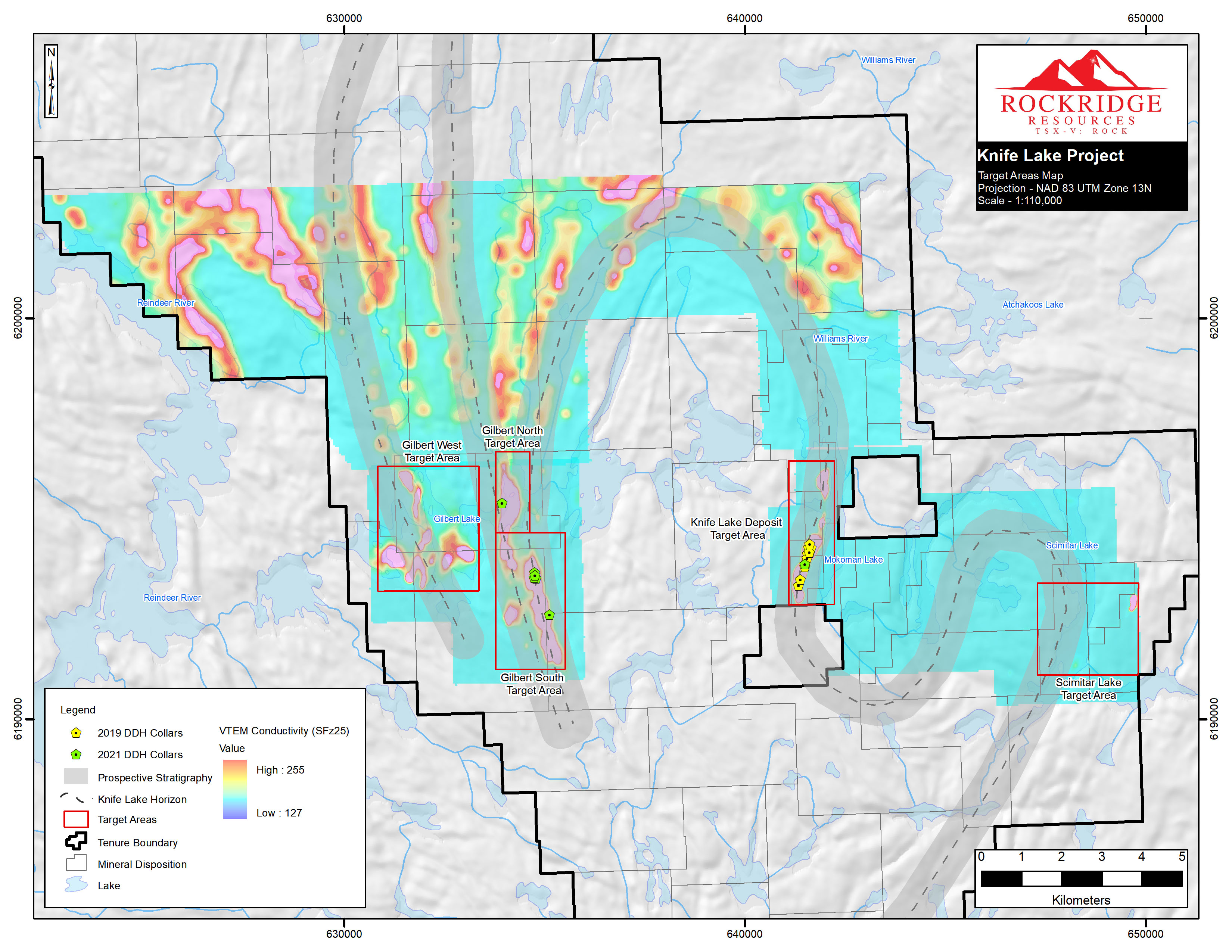
Most of the drill program targeted the Gilbert Lake area located ~5-6 km west of the Knife Lake Deposit and consists of a prospective 15km long trend
There is strong discovery potential in and around the deposit as well as at regional targets on the Property; modern exploration techniques and methods are being utilized with the goal of making new discoveries
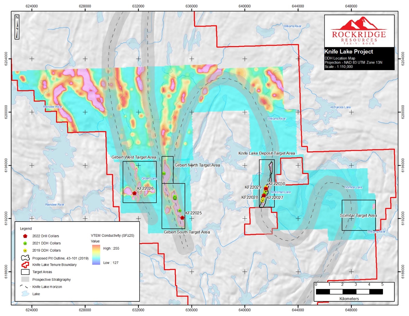
The Company drilled a total of 939 metres in six drill holes in 2022 and has received assays and completed interpretation for all holes
Drilling focused on discovering VMS-style copper deposits along newly defined conductors at Gilbert South and Gilbert West as well as at the Knife Lake VMS deposit
Planning is underway for 2024/25 exploration programs
The Company announced it has completed its 3D Geophysical Plate Modelling of the recently acquired VTEM data which was used to further refine targeting for Rockridge’s completed summer 2022 drill program
The VTEM survey data displays up to 15 km strike length of highly conductive near-surface anomalies hosted in prospective stratigraphy in regional target areas, including the Gilbert Lake targets
Regional target areas, which include Gilbert Lake targets, were previously identified through geological mapping, surface sampling and geochemical analysis as stratigraphy with high potential to host valuable copper occurrences; this stratigraphy is interpreted to be the same horizon that hosts the Knife Lake deposit
Rockridge has signed all major contracts including the drilling contractor, camp construction, and helicopter rental. Additionally, the Company has received its Exploration Permit which expires in February 2024 and hence can conduct drilling, geophysical works and prospecting
The Company continues to gain an understanding and knowledge of the geology and the recent results from the 2022 drill program are supportive of the thesis that Gilbert is part of a larger system common with VMS-style deposits
Plan to continue exploration efforts in 2024/25
The focus of the 2022 drill program was continued infill and expansion drilling at the deposit, with the intent of upgrading existing mineral resource estimates and to better understand the geology at the Knife Lake Deposit. In addition to the deposit drilling, exploratory drill holes were completed at the highly prospective Gilbert Lake target area. The program consisted of 936m total metres drilled in six drill holes with four holes drilled at the deposit. The Company has received assays and completed interpretation for all holes.
Knife Lake Target Areas 2022 Drill Program:

The Gilbert Lake targets were identified from the results and interpretation of the previous geophysical, drill and field programs. Results from these programs show that airborne VTEM surveys can successfully identify zones of VMS-style mineralization hosted in favourable stratigraphy on the property. The drilling at the Gilbert Lake South target area further investigated strike-length continuity of the mineralized horizon intersected in 2021 drilling, which remains open to the south. The holes also evaluated potential zoning of mineralization, which is commonly observed in VMS systems.
2022 Drill Program Drill Collar Locations:
Drilling at a newly discovered copper showing at the Gilbert West Area targeted the down-dip extension of a mineralized and intensely altered volcanic package which is interpreted to be the Knife Lake stratigraphic horizon. The Gilbert West target had never been drill tested. Rockridge is planning follow-up exploration programs at Knife Lake and has received its exploration permit which is good through February 2024.
Knife Lake Deposit Diamond Drill Hole Results and Geological Summary:
Drill holes KF22027, KF22028 and KF22029 were designed to follow-up on the 2019 resource drilling program and infill historic drilling at the Knife Lake Deposit. Mineralization forms semi-massive to massive and net textured pyrite-pyrrhotite-chalcopyrite-sphalerite hosted in intermediate-mafic volcanics and green pegmatite intervals.
| From | To | Core Length | Cu | Au | Ag | Zn | Co | CuEq | |
| (m) | (m) | (m) | (%) | (g/t) | (g/t) | (%) | (%) | (%) | |
| KF22027 | |||||||||
| 31.35 | 50.35 | 19.00 | 0.68 | 0.09 | 2.77 | 0.12 | 0.01 | 0.86 | |
| including | 31.35 | 35.50 | 4.15 | 0.50 | 0.07 | 2.22 | 0.10 | 0.00 | 0.61 |
| and | 38.45 | 42.85 | 4.40 | 1.42 | 0.16 | 4.85 | 0.20 | 0.02 | 1.76 |
| including | 39.95 | 40.50 | 0.55 | 3.39 | 0.39 | 13.45 | 0.56 | 0.00 | 4.00 |
| and | 48.00 | 50.35 | 2.35 | 1.33 | 0.19 | 5.59 | 0.28 | 0.01 | 1.70 |
| KF22028 | |||||||||
| 23.55 | 42.23 | 18.68 | 0.42 | 0.05 | 1.61 | 0.21 | 0.01 | 0.60 | |
| including | 23.55 | 26.15 | 2.60 | 0.40 | 0.06 | 1.94 | 0.65 | 0.00 | 0.73 |
| including | 24.42 | 24.92 | 0.50 | 0.78 | 0.13 | 3.42 | 2.26 | 0.00 | 1.80 |
| and | 29.45 | 39.45 | 10.00 | 0.62 | 0.06 | 2.27 | 0.20 | 0.01 | 0.85 |
| including | 38.45 | 39.45 | 1.00 | 1.23 | 0.09 | 4.03 | 0.11 | 0.04 | 1.67 |
| 52.50 | 55.38 | 2.88 | 0.26 | 0.02 | 0.97 | 0.06 | 0.00 | 0.33 | |
| 61.00 | 67.10 | 6.10 | 0.50 | 0.04 | 2.27 | 0.10 | 0.01 | 0.63 | |
| KF22029 | |||||||||
| 13.00 | 28.75 | 15.75 | 1.91 | 0.23 | 7.79 | 0.30 | 0.01 | 2.32 | |
| including | 17.35 | 23.50 | 6.15 | 2.84 | 0.31 | 11.81 | 0.56 | 0.01 | 3.42 |
| including | 19.67 | 23.50 | 3.83 | 3.79 | 0.39 | 15.86 | 0.42 | 0.01 | 4.41 |
| including | 20.40 | 20.90 | 0.50 | 12.60 | 0.65 | 46.60 | 1.18 | 0.00 | 13.94 |
| 25.00 | 28.75 | 3.75 | 2.41 | 0.26 | 9.43 | 0.19 | 0.01 | 2.83 | |
| including | 28.00 | 28.75 | 0.75 | 3.80 | 0.53 | 17.35 | 0.25 | 0.03 | 4.65 |
Drill hole KF22030 was designed to follow-up on the 2019 and 2021 resource drilling program and infill historic drilling at the Knife Lake Deposit. Mineralization forms semi-massive to massive and net textured pyrite-pyrrhotite-chalcopyrite-sphalerite hosted in intermediate-mafic volcanics and green pegmatite intervals.
| Hole ID | Easting (m)* | Northing (m)* | Elev. (m) | Az. (°) | Dip (°) | Final Depth (m) |
| KF22025 | 635325 | 6192055 | 383 | 261 | -64 | 416 |
| KF22026 | 631719 | 6193913 | 364 | 114 | -50 | 242 |
| KF22027 | 641451 | 6193746 | 384 | 283 | -44 | 92 |
| KF22028 | 641452 | 6193746 | 384 | 283 | -90 | 74 |
| KF22029 | 641592 | 6194255 | 386 | 285 | -65 | 53 |
| KF22030 | 641592 | 6194255 | 386 | 285 | -90 | 62 |
*Coordinates projected in NAD83 UTM Zone 13N
Hole KF22030:
Drill hole KF22030 intersected a broad zone of mineralization over 15.90m (from 13.80m - 29.70m) which returned 1.93% Cu, 0.26 g/t Au, 7.50 g/t Ag, 0.17% Zn and 0.02% Co (2.35% CuEq), and includes 2.18% Cu, 0.27 g/t Au, 7.83 g/t Ag, 0.19% Zn, 0.02% Co (2.65% CuEq) over 9.00m (from 17.00m - 26.00m).
| From | To | Core Length | Cu | Au | Ag | Zn | Co | CuEq | |
| (m) | (m) | (m) | (%) | (g/t) | (g/t) | (%) | (%) | (%) | |
| KF22030 | |||||||||
| 13.80 | 29.70 | 15.90 | 1.93 | 0.26 | 7.50 | 0.17 | 0.02 | 2.35 | |
| including | 17.00 | 26.00 | 9.00 | 2.18 | 0.27 | 7.83 | 0.19 | 0.02 | 2.65 |
* Drill indicated intercepts (core length) are reported as drilled widths; true thickness is undetermined.
** No cutoffs or metal recoverability were factored into CuEq calculations.
*** Assumptions used in USD for the copper equivalent calculation were metal prices of $3.38/lb Cu, $23.56/lb Co, $1,649.30/oz Au, $18.42/oz Ag, $1.32/lb Zn. Copper equivalent (CuEq) was calculated using the formula CuEq = Cu% + ((Zn%*Zn Price*22.0462) + (Co%*Co Price*22.0462)+ (Augpt*Au Price/31.1035) + (Ag *Ag Price/31.1035)) / (Cu price*22.0462).
Gilbert Lake South Diamond Drill Hole Results and Geological Summary:
Hole KF22025:
Hole KF22025 hole was designed as a 600m strike length step-out from hole KF21017 drilled in 2021. Geophysical modeling on the 2021 airborne VTEM Plus and borehole EM data revealed that hole KF21017 did not intersect the main prospective conductive body and requiring further investigation to determine the source of the anomaly. Hole KF22025 successfully intersected two intervals of green tonalitic pegmatite, interpreted to be the same horizon that hosts the Knife Lake deposit. Net-textured semi-massive pyrrhotite-pyrite with trace chalcopyrite mineralization and graphite alteration was present between 286.50m-303.35m and 360.50m-376.10m. The lower intersection correlates well with the prospective borehole EM conductor, with a projected intersection at 355.00m, and is interpreted to be the source of the targeted geophysical anomaly. Assays from these intervals did not return results of economic significance.
Hole KF22026:
Drill Hole KF22026 was the first hole drilled at the newly discovered Gilbert West target area. The 2021 airborne VTEM survey identified strong conductivity and related magnetic high anomalies forming bedding parallel conductors which correlated to highly prospective stratigraphy interpreted to be the same stratigraphic horizon that hosts the Knife Lake Deposit. The hole intersected intermediate and mafic metavolcanics with green tonalitic pegmatites that hosted intervals of semi-massive pyrrhotite, associated with graphitic alteration. Logging identified trace chalcopyrite intergrown with semi-massive pyrrhotite, interpreted to represent VMS-style mineralization. The geology in these intervals is very encouraging and warrants following up which will be considered in a 2024 exploration program.